
Purpose-Led Scan-to-BIM Services
BIMscan Ltd provides high-accuracy 3D laser scanning and Scan-to-BIM services tailored to mechanical, electrical and public health (M&E) projects. Our focus is simple—deliver reliable, structured data that supports coordination, design and construction without unnecessary complexity.
At BIMscan Ltd, we provide structured, high-quality scanning services that support real-world design and construction workflows. Using advanced 3D laser scanning technology and hands-on M&E experience, we capture accurate site information that reduces uncertainty, improves coordination, and helps teams make informed decisions earlier in the project lifecycle.
The Technology - FARO Blink™
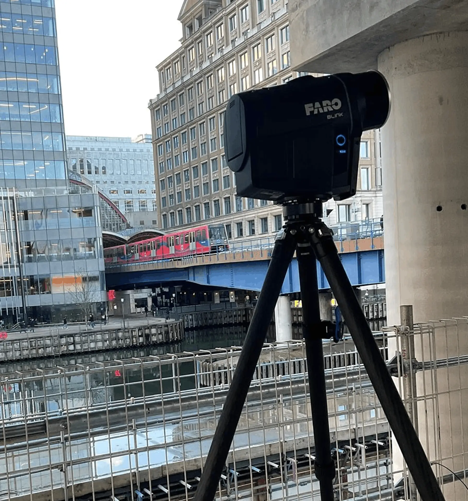
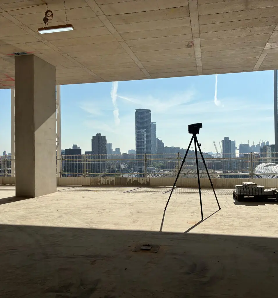
We use the FARO Blink™ imaging laser scanner to capture high-accuracy 3D measurements and immersive 360° imagery quickly and efficiently.
Mounted on a tripod, the scanner performs a full 360° scan in approximately 30 seconds—significantly faster than traditional scanning systems. As the scanner moves through a building, millions of precise measurement points are captured and stitched together to create a complete digital representation of the space.
Alongside the point cloud data, high-definition 360° photography is also recorded at every scan position, creating a fully navigable visual record of the building.
- Rapid on-site capture with minimal disruption
- Accurate point cloud data for BIM workflows
- HD 360° imagery for remote site access
- Efficient scanning across live environments
- Structured outputs ready for coordination and modelling
Accurate Data for Better Project Decisions
Our services are designed to provide accurate, usable site information for consultants, contractors and BIM teams working across complex environments.
Whether the requirement is refurbishment planning, coordination validation, as-fitted documentation or remote building access, our approach remains the same—capture the information that matters most and deliver it in a format that supports efficient project delivery.

- Real Construction Expertise: 25+ years on live projects means we think like installers, not just modellers.
- Buildable, Practical Outputs: Our drawings and models are designed to work in the real world.
- Flexible Support: Scale up resources without the cost of permanent staff.
- Clear, Fast Communication: No jargon, no delays – just responsive, straight answers.
- Trusted by Industry Leaders: Repeat work with respected contractors and consultants across the UK.
Simple, Efficient and Built Around Your Project
Our approach is shaped by experience in complex M&E environments, where accuracy and coordination are critical.
We focus on capturing the areas that have the greatest impact on design and installation—rather than scanning everything without distinction.
Site Assessment & Planning
We review the project requirements, identify key coordination areas and determine the most effective scanning strategy based on the building and intended use of the data.
On-Site Reality Capture
Using the FARO Blink™, we carry out fast, high-accuracy scanning with minimal disruption to the site or surrounding operations.
Data Processing & Registration
The captured scan data is processed, aligned and stitched together into a structured, navigable point cloud environment.
Delivery & Collaboration
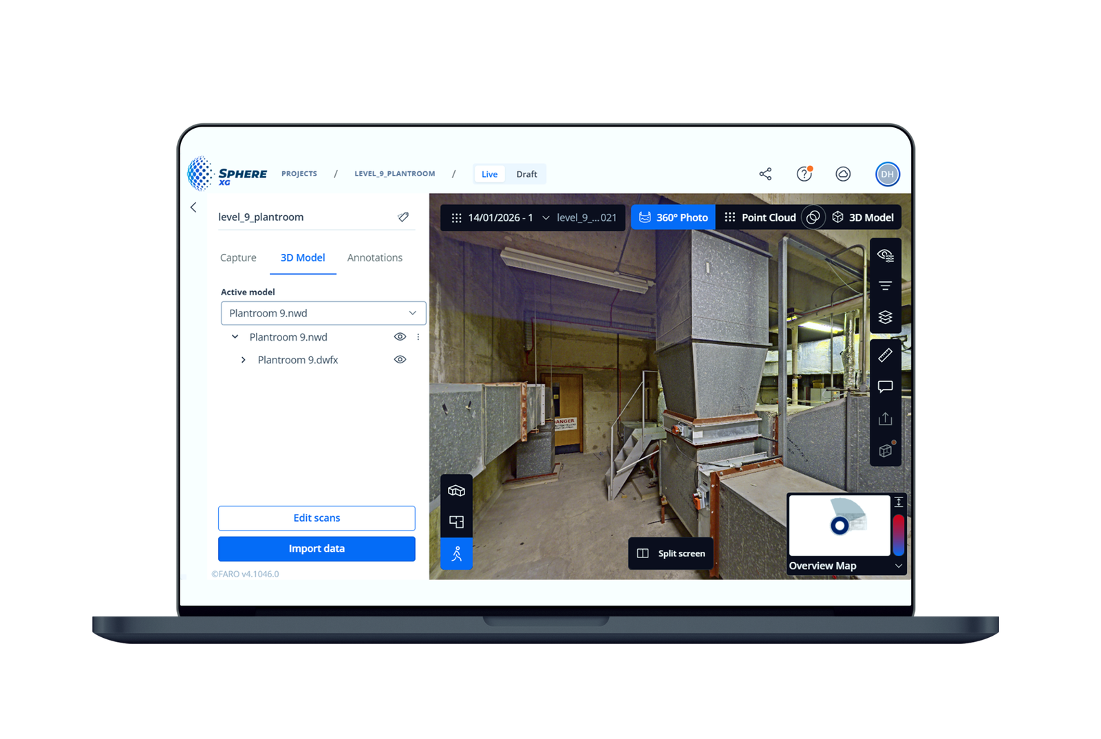
Final outputs are delivered in the required formats and can be published to Sphere XG for remote viewing, measurement and collaboration.
As-Fitted Documentation & Refurbishment Surveys
Accurate Existing Conditions Without Assumptions
Refurbishment and retrofit projects often begin with incomplete, outdated or missing information. Traditional surveys can be slow, disruptive and prone to gaps in data.
Our scanning process captures the building exactly as it exists at the time of survey—including structure, finishes and existing MEP services.
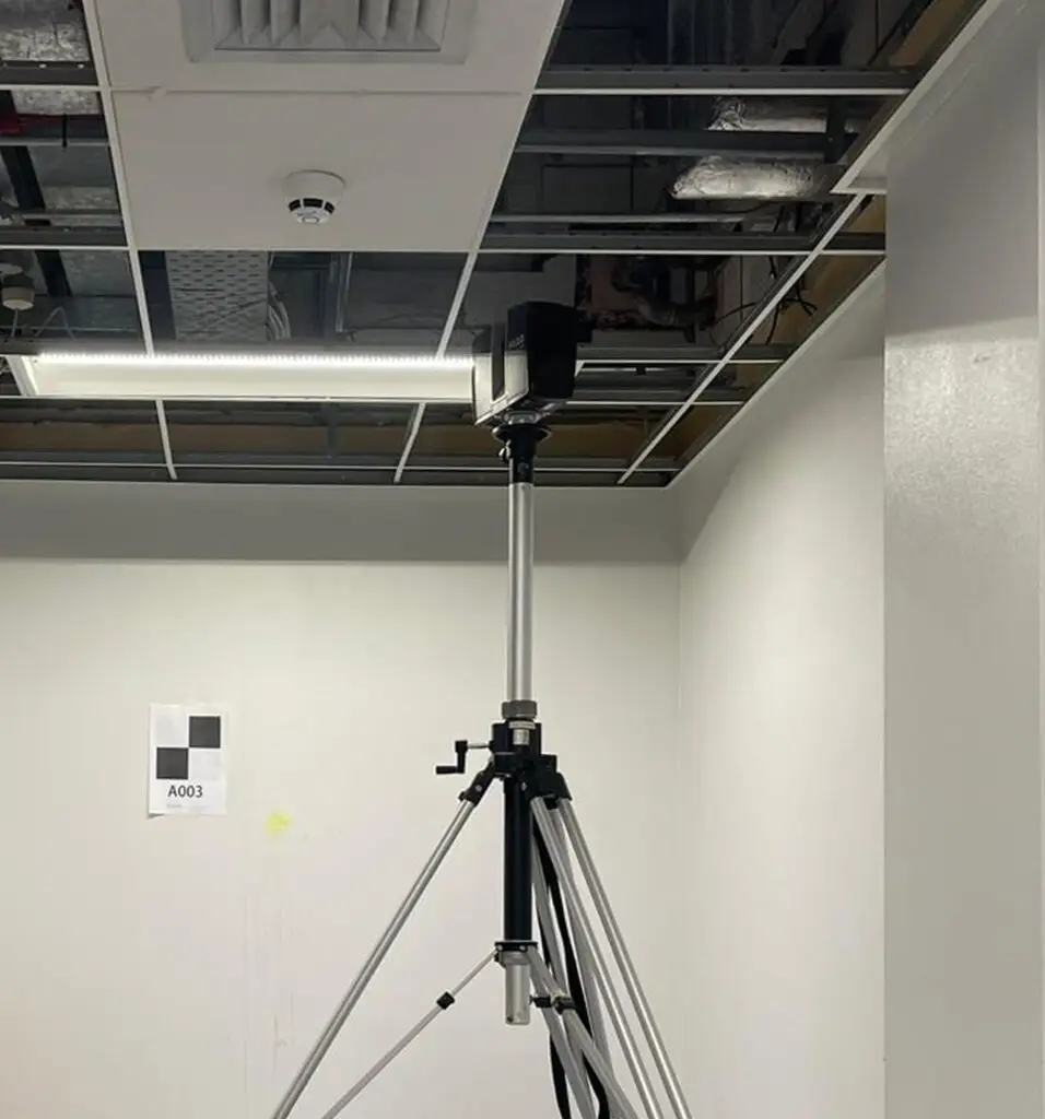
Using an extendable tripod system, we can also safely capture data within ceiling voids and other difficult-to-access areas, providing accurate visibility of concealed services without extensive access equipment or disruptive opening-up works.
This provides project teams with a reliable as-fitted record that supports:
- Refurbishment planning
- Existing condition surveys
- Coordination of new services
- Design validation and risk reduction
Rather than fully modelling all existing services, teams can coordinate new installations directly against the scan data itself—saving both time and cost while improving accuracy.
Using Sphere XG, clients and design teams can remotely walk through the building in full 360° detail, inspect existing conditions and review spaces collaboratively from any device.
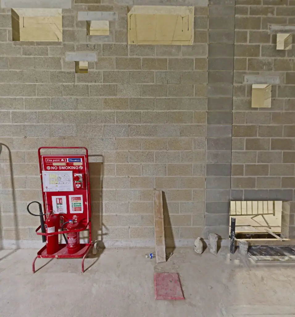
Buildersworks Hole Verification
Identify Problems Before Installation Begins
Incorrect builder’s work openings can create major issues during MEP installation—leading to delays, costly remedial works and coordination disputes.
We scan structural openings once formed and compare the captured data directly against the project’s BIM model. Any discrepancies can then be identified and resolved before installation begins.
Why it Matters
Updating a digital model is significantly quicker and more cost-effective than rectifying issues on site.
This process allows teams to:
- Verify opening locations accurately
- Reduce installation risk
- Avoid structural remediation
- Improve coordination confidence
Derelict & Vacant Building Scanning
Remote Building Access for Developers & Investors
For owners of vacant or derelict buildings, repeated site visits can be difficult to manage and often discourage early-stage developer engagement.
We capture the entire building in a single visit—providing accurate measurements and immersive 360° imagery throughout the property.
Using Sphere XG, developers, architects and investors can then remotely explore the building from their desk, without needing immediate physical access.
Stakeholders can:
- Review accurate dimensions remotely
- Assess building condition visually
- Revisit spaces at any time
- Explore opportunities before arranging site visits
This creates a far more efficient early-stage review process for everyone involved.
Accessible Anywhere with Sphere XG
All scan data can be published to Sphere XG—a browser-based platform that allows teams to explore and interact with the scanned environment remotely.
No specialist software is required. Users simply access the project through a secure link.
Using Sphere XG, Teams Can:
- Navigate the site virtually in 360°
- Measure distances and heights directly in-browser
- Review point cloud data from any angle
- Jump between scan locations instantly
- Access information on desktop, tablet or mobile
Start Your Next Project with Accurate Information
Whether you’re planning a refurbishment, validating coordination, or capturing an existing building condition, BIMscan Ltd provides reliable Scan-to-BIM services designed around real project requirements.
Talk to us about your project and how accurate reality capture can support better decisions across design, coordination and construction.